cosermap logo
Local Weather
7-Day Forecast
Show Local Weather
Loading...

love chunibyo other delusions heart throb seta riverhashishitaseta river hashi shita

Love, Chunibyo & Other Delusions - Heart Throb -

Osaka

Episode
Ep. 12
Time
18m 24s
love chunibyo other delusions heart throb seta riverhashishitaseta river hashi shita
  • Nearest Station: Keihan Ishiyama-Sakamoto Line: Karahashi-mae Station
  • Walk: About 18 minutes on foot
  • Best time to visit: Late afternoon on a clear day for bridge shadows and river atmosphere similar to the anime
  • Crowd level: Usually quiet
  • Rikka and Yuta share a quiet, intimate moment beneath the bridge along the Seta River in episode 12.
  • This moment appears during the emotional winding-down of the story, when Rikka and Yuta come to the riverbank beneath Seta Ohashi Bridge and face their feelings in a quieter setting. After confusion, arguments, and anxiety about the future, their exchange is no longer just playful chuunibyo banter, but something more open, dependent, and understanding. The mood is soft and still, as if the riverside at the edge of the city finally gives them space to pause, confirm their bond, and prepare for the clearer direction of their relationship. In real life, this scene corresponds to the riverside area under Seta Ohashi Bridge in Otsu, Shiga, and the anime reproduces the bridge structure, the openness of the river, and the layout of the embankment path with impressive accuracy. The shadow under the bridge and the line of sight along the water make the location easy to recognize. Compared with the anime, the real site may differ slightly in railings, pavement, plant growth, and small facilities depending on the season and year, and warning signs or public notices are usually more visible. The anime simplifies some visual clutter and modern infrastructure to keep the frame cleaner and more emotional, but the real location still matches very well and is an excellent spot for anime pilgrimage photography.
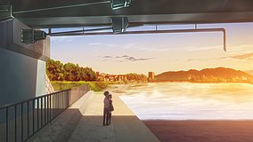
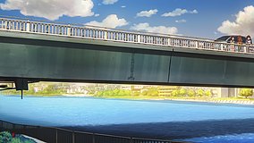
Can I walk right under Seta Ohashi Bridge to match the anime angle?
Yes, the riverside path and spaces under the bridge are generally accessible on foot, but conditions can vary after rain or river maintenance work. Wear shoes with good grip if you plan to move closer to the embankment.
Is there a good Google Street View match for this Love, Chunibyo scene?
Street View coverage nearby is useful for confirming bridge structure and approach roads, but the exact under-bridge angle may be easier to verify with satellite view and fan pilgrimage photos. The riverside geometry still makes the match quite clear.
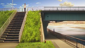
Are there any photography restrictions or etiquette concerns at this spot?
There are no known anime-specific restrictions, but this is a public riverside area, so avoid blocking paths, climbing barriers, or entering unsafe slopes. Be especially careful during strong river winds or high-water periods.

© 2026 Coser Map. All rights reserved.