cosermap logo
Local Weather
7-Day Forecast
Show Local Weather
Loading...

love chunibyo other delusions heart throb seta river bridge

Love, Chunibyo & Other Delusions - Heart Throb -

Osaka

Episode
Ep. 1
Time
14m 2s
love chunibyo other delusions heart throb seta river bridge
  • Nearest Station: Keihan Ishiyamadera Station (Keihan Ishiyama-Sakamoto Line)
  • Walk: 18 minutes on foot
  • Best time to visit: Late afternoon on a clear day for wide river views similar to the anime establishing shot
  • Crowd level: Usually quiet
  • A distant establishing shot shows the Seta River and bridge under a calm sky, setting the everyday tone of the episode.
  • This shot uses a distant view of the Seta River and bridge as an establishing transition, introducing the calm riverside atmosphere that defines the everyday feel of Love, Chunibyo & Other Delusions - Heart Throb -. In episode 1, the story continues the relationships from the previous season while resetting the rhythm of Yuta, Rikka, and their friends’ lives, so a character-free landscape cut like this helps viewers settle back into the familiar setting. The mood here is gentle and stable, suggesting that a new school term and subtle changes in the characters’ relationships are about to begin, before the episode moves into the shy, sweet, and slightly chaotic energy of youthful daily life. In real life, the scene closely recreates the broad river view around Seta River Bridge, especially the width of the waterway, the outline of the bridge, and the layered urban scenery along the banks, making it highly recognizable. Compared with the anime, the real location shows seasonal and year-by-year differences in vegetation, railings, roadside fixtures, and distant buildings, while the anime presents a cleaner and brighter visual arrangement. This spot is identified less by prominent signage than by the bridge shape, the direction of the river, and the surrounding skyline, so checking maps or Street View makes matching the angle much easier. Overall, it is a location where the atmosphere is reproduced very faithfully, even if some fine details are polished in the anime, making it an excellent place for wide-angle pilgrimage comparison photos.
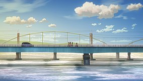
Can I recreate this bridge-and-river shot from a public area?
Yes. The riverside and bridge approaches are viewable from public roads and pedestrian areas, so you can compare the skyline and river angle without entering private property.
Is there a specific sign marking this as a Chunibyo pilgrimage spot?
No official anime sign is typically installed at this viewpoint. Fans usually identify it by the Seta River Bridge profile, river direction, and online pilgrimage maps.
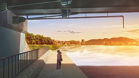
What is the best tool for matching the anime angle before visiting?
Google Maps and Street View are the most practical options for pre-checking approach roads and bridge sightlines. They help a lot because this scene is recognized more by landscape composition than by signage.

© 2026 Coser Map. All rights reserved.