cosermap logo
Local Weather
7-Day Forecast
Show Local Weather
Loading...

love chunibyo other delusions heart throb seta no karahashi bridge

Love, Chunibyo & Other Delusions - Heart Throb -

Osaka

Episode
Ep. 11
Time
5m 19s
love chunibyo other delusions heart throb seta no karahashi bridge
  • Nearest Station: Keihan Ishiyama-Sakamoto Line: Karahashimae Station
  • Walk: 8 minutes on foot
  • Best time to visit: Late afternoon on a clear day for bridge and river views close to the anime mood
  • Crowd level: Usually quiet
  • Rikka and Yuuta stand by the riverside near the bridge, framed against the calm Seta River embankment.
  • This scene appears as the story’s emotions begin to converge, with Rikka and Yuuta walking together by the Seta River bridge in a quiet atmosphere filled with unease and a sense of intimacy only the two of them can share. As the tension between reality and chunibyo fantasy becomes harder to ignore, Rikka feels lost about her feelings and her future, while Yuuta stays by her side and tries to ease her anxiety with gentle honesty. Rather than presenting a dramatic clash, the anime uses the calm riverside and bridge walkway to highlight a subtle but important shift in their relationship; before this moment, the two have already built up pressure and misunderstanding, and after it, they move closer to truly facing each other’s feelings. The real-life match is the east bank area of the Seta River bridge, where the anime recreates the landform, river course, bridge placement, and embankment path with impressive accuracy. The angle of the bridge crossing the river and the open view from the east bank are especially easy to compare with the anime frame. In reality, the site feels less polished than the animation, with more visible modern road fixtures, guardrails, pavement markings, and traffic signage, giving it a stronger everyday atmosphere. A comparison through Google Street View or on foot shows that the anime preserved the overall background structure while simplifying some signs, greenery, and nearby man-made details. Since this is fundamentally a bridge approach and riverside transit space rather than a dedicated sightseeing photo spot, visitors should stay aware of pedestrians, bicycles, and traffic, though that ordinary setting is also what makes the location feel so close to the mood of the series.
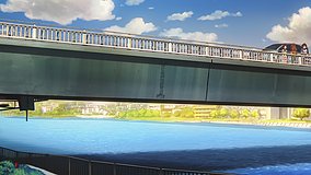
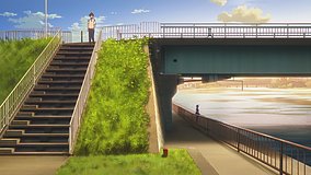
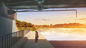
Is the east bank viewpoint at Seta River easy to access for anime pilgrimage photos?
Yes, the riverside approach near the bridge is publicly accessible on foot, but it is part of an active road and embankment area, so watch for traffic and cyclists while framing shots.
Can I use Google Street View to match this Chuunibyo scene before visiting?
Yes, Street View is useful here because the bridge alignment, embankment, and road layout are clearly visible, making pre-trip angle checking much easier.
Are there any official anime signs or pilgrimage markers at this exact bridge spot?
There are no widely known official series signboards at this exact east bank point, so most fans identify it by the bridge shape, riverbank geometry, and surrounding road features.

© 2026 Coser Map. All rights reserved.