cosermap logo
Local Weather
7-Day Forecast
Show Local Weather
Loading...

shirobako sakai crossing

SHIROBAKO

Tokyo

Episode
Ep. -
Time
-
shirobako sakai crossing
  • Nearest Station: Musashi-Sakai Station (JR Chuo Line / Seibu Tamagawa Line)
  • Walk: About 15–20 minutes on foot
  • Best time to visit: Late morning or afternoon on a clear day for easier angle matching and brighter photos
  • Crowd level: Moderate
  • Aoi Miyamori is shown against an ordinary suburban street intersection, emphasizing SHIROBAKO's grounded working-life atmosphere.
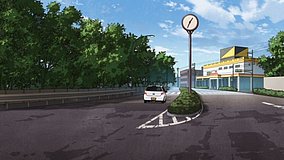
  • This moment appears within SHIROBAKO’s everyday commuting and work-driven atmosphere, showing Aoi Miyamori alone at or passing through a street corner with a thoughtful, slightly pressured expression that reflects the tension she often carries as part of an anime production team. Rather than being a dramatic climax, the scene uses an ordinary city backdrop to highlight how she is constantly moving between work duties and daily life. The surrounding story usually connects to her heading to the studio, contacting subcontractors, or briefly collecting herself amid a hectic schedule, so her emotions here blend fatigue with quiet determination. In real life, this is the Sakai Crossing area in Musashino, Tokyo, and the overall road layout, openness of the intersection, and corner building placement match the anime quite closely, making it clear that the staff drew from the real location. The anime simplifies signage, utility lines, and storefront details to create a cleaner composition, while the real site naturally shows changes over time such as updated signs, adjusted traffic markings, growing trees, or renovated facades. Even so, the intersection’s spatial feel, road width, and turning perspective remain highly recognizable, and a comparison with the actual site or Google Street View shows this to be a very faithfully adapted SHIROBAKO pilgrimage spot.
Is Sakai Crossing easy to photograph for a SHIROBAKO pilgrimage?
Yes, it is a public street intersection and can be photographed from the sidewalk, but be careful not to block pedestrians or step into the roadway while matching the anime angle.
What is the best way to compare the anime frame with the real location?
Fans usually check Google Street View first, then recreate the shot on site from the corner sidewalk because the road shape and intersection depth are easier to recognize that way.
Are there any nearby SHIROBAKO-related spots to visit after this scene location?
Yes, this area is part of the broader Musashino and western Tokyo setting model for SHIROBAKO, so many fans combine it with Musashino-related locations and stations along the Chuo Line for a half-day pilgrimage route.

© 2026 Coser Map. All rights reserved.