cosermap logo
Local Weather
7-Day Forecast
Show Local Weather
Loading...

shirobako sakurabashi crossing

SHIROBAKO

Tokyo

Episode
Ep. -
Time
-
shirobako sakurabashi crossing
  • Nearest Station: Musashi-Sakai Station (JR Chuo Line / Seibu Tamagawa Line)
  • Walk: about 20 minutes on foot
  • Best time to visit: Late morning or early afternoon on a clear day for lighting similar to the anime
  • Crowd level: Moderate
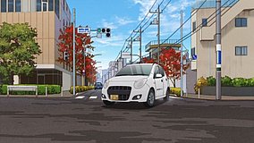
  • A quiet urban intersection frame in SHIROBAKO captures the everyday streetscape around Sakurabashi Crossing as a transitional city moment.
  • This moment does not focus on character expressions, instead using a street intersection as a transitional shot to create the grounded urban rhythm that defines SHIROBAKO. Scenes like this often appear before or after characters move between locations, commute, or head to work, helping establish the Musashino area as both a living neighborhood and a professional space. The mood here is quiet and slightly reflective, with the feeling of collecting one’s thoughts before the next task begins. In real life, Sakurabashi Crossing matches the anime quite well in its overall composition, especially the road layout, the openness of the junction, and the scale of the surrounding residential streets, showing that the staff clearly referenced the real location. The anime simplifies wires, signs, and building details to keep the frame cleaner and easier to read, while the actual site includes more everyday traffic signage, road markings, and street-corner fixtures. Comparing it with Google Street View or visiting in person makes it clear that the strongest match lies in the shape of the intersection and the viewing angle, while vegetation, storefront appearances, and some signage may have changed over time, so framing based on the road geometry and building mass is the best approach.
Is Sakurabashi Crossing easy to photograph for a SHIROBAKO comparison shot?
Yes, it is a public street intersection and can be photographed from sidewalks, but stay clear of traffic and avoid blocking pedestrians while lining up the anime angle.
What is the best tool to confirm the exact anime viewpoint before visiting?
Google Street View is the most useful way to preview the junction shape, road markings, and building alignment before you go, especially since minor signage can change over time.
Are there useful amenities nearby for anime pilgrims visiting this spot?
Yes, the wider Musashi-Sakai and Musashino area has convenience stores, cafés, and restrooms around the station area, so many visitors combine this crossing with a broader SHIROBAKO location walk.

© 2026 Coser Map. All rights reserved.