cosermap logo
Local Weather
7-Day Forecast
Show Local Weather
Loading...

kitayama first tunnel

SeaBed

Kyoto

Episode
Ep. -
Time
-
kitayama first tunnel
  • Nearest Station: Nose Electric Railway Myoken Line, Myokenguchi Station
  • Walk: About 55–70 minutes on foot, so a taxi or local bus is more practical
  • Best time to visit: Late morning to afternoon on a clear day, especially in spring or autumn for lighting close to the anime mood
  • Crowd level: Usually quiet
  • A quiet mountain road leads toward a tunnel entrance, creating a subdued transitional moment in SeaBed.
  • This moment captures a brief pause as the story passes along a mountain road, and even though no character is clearly shown, the empty roadway, tunnel entrance, and still atmosphere give the scene a reflective mood. The surrounding context suggests a point where the characters are sorting through their feelings and memories, making the location feel like an emotional transition marked by faint unease, loneliness, and a quiet push toward what comes next. Compared with the real Kitayama-First-Tunnel, the anime reproduces the road alignment, the position of the tunnel entrance, the enclosing mountain walls, and the guardrails with impressive accuracy, so the composition is easy to match on site. In real life, vegetation, road resurfacing, traffic mirrors, and signage may differ slightly depending on when you visit, and some signs may look newer or more detailed than in the simplified anime version. Even so, the essential topography, the curve of the road before the tunnel, and the enclosed mountain feeling remain highly consistent, making this a very recognizable pilgrimage spot. A comparison with on-site photos or Google Street View shows how directly the series referenced the real location, although the anime uses cleaner colors and a more emotional visual tone.
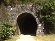
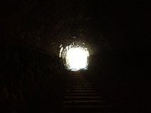
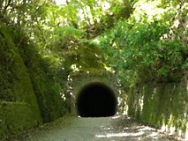
Can I safely recreate the SeaBed tunnel shot at Kitayama-First-Tunnel?
You can photograph the area from the roadside, but it is an active mountain road, so avoid standing in the lane or near tunnel traffic. A quick stop with careful positioning is the safest approach.
Is there public transport close to Kitayama-First-Tunnel?
The nearest rail access is Myokenguchi Station, but the tunnel is not a short walk from there. Most visitors use a taxi, drive, or combine rail with limited local transport depending on the day.
Does Google Street View help match the SeaBed background here?
Yes, Street View is useful for checking the road curve, guardrails, and tunnel placement before visiting. It helps fans line up the composition in advance and decide the safest photo angle.

© 2026 Coser Map. All rights reserved.