cosermap logo
Local Weather
7-Day Forecast
Show Local Weather
Loading...

jr fukuchiyama line abandoned line hiking trail

SeaBed

Kyoto

Episode
Ep. -
Time
-
jr fukuchiyama line abandoned line hiking trail
  • Nearest Station: JR Namaze Station (JR Takarazuka Line / Fukuchiyama Line)
  • Walk: 25–35 minutes on foot
  • Best time to visit: Late morning to afternoon in spring or autumn for safer trail conditions and lighting similar to the anime
  • Crowd level: Moderate
  • A quiet outdoor shot captures the abandoned railway hiking trail area surrounded by greenery, emphasizing stillness over character action.
  • This scene uses an empty landscape shot to convey a pause as the characters pass through the abandoned railway trail area, with no dramatic action and instead letting the forest, rail remnants, and silence carry the mood. It feels like a moment in the story when the characters are sorting out their thoughts and letting their relationships settle, creating a quiet, reflective, slightly melancholy atmosphere that still suggests moving forward. In real life, the Fukuchiyama Line Abandoned Line Hiking Trail is defined by an old rail corridor, rocky mountain walls, and dense greenery, and the anime recreates the route’s terrain and enclosed natural atmosphere quite faithfully. On site, the area functions as a maintained hiking course with route guidance and safety notices, though seasonal vegetation, railings, and path conditions can differ from the anime. Compared with the real location, the anime simplifies signs, man-made structures, and traces of other visitors, giving the scene a more purely silent and emotional feel.
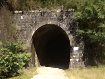
Which station is best for reaching the SeaBed scene at the Fukuchiyama abandoned line?
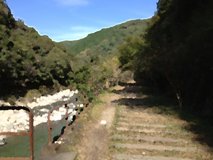
JR Namaze Station is the usual starting point for the hiking trail and the most practical rail access for this scene. From there, most visitors walk to the trail entrance in about 25 to 35 minutes.
Can I freely photograph at the Fukuchiyama Line abandoned trail?
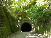
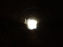
Yes, casual photography is generally fine on the public hiking route, but tripods or blocking the path can bother other hikers. Be extra careful in tunnels and avoid dangerous edge shots.
Are there current access or safety issues anime fans should know before visiting?
This former rail line is a hiking course, so conditions can change after heavy rain, storms, or maintenance work. Check local hiking and city tourism updates before going, and bring a flashlight if your route includes tunnels.

© 2026 Coser Map. All rights reserved.