cosermap logo
Local Weather
7-Day Forecast
Show Local Weather
Loading...

picnic sumida 5 chome sports ground

Picnic

Tokyo

Episode
Ep. -
Time
-
picnic sumida 5 chome sports ground
  • Nearest Station: Horikiri Station (Tobu Skytree Line)
  • Walk: 18 minutes on foot
  • Best time to visit: Late afternoon in spring or autumn for soft light and a similar riverside atmosphere
  • Crowd level: Usually quiet
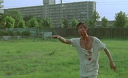
  • A quiet riverside sports ground and embankment are shown in a calm establishing shot from Picnic.
  • This moment presents one of the calmer everyday scenes in the work, bringing the characters to an open riverside space where the pace briefly slows after busier or more uneasy developments. The focus is not on dramatic action but on the atmosphere created by the setting and the way the characters’ feelings settle into something quieter and more relaxed, as if they are sharing a brief but precious break together before the next conversation or event. The real-world match is Sumida 5-chome Sports Ground in Tokyo’s Sumida Ward, and its broad riverbank atmosphere is very close to the anime version. The embankment slope, grassy open area, and sports-ground layout all reflect the geography seen in the scene, especially the wide riverside view and the low-profile facilities. That said, the anime simplifies some surrounding details such as railings, ground markings, signs, sports equipment, and the density of distant buildings to create a cleaner composition. When visiting in person, you may notice more safety notices, usage boards, and seasonal differences in the grass and vegetation. Compared with on-site photos or Street View, the anime is highly accurate in its overall shapes and spatial relationships, while smaller elements like sign text, facility condition, and tree growth differ slightly.
Can I freely enter Sumida 5-chome Sports Ground to recreate the anime shot?
Yes, the riverside area is generally open to the public, but specific sports sections may be reserved or in use. Stay outside active play areas and avoid blocking local users when taking photos.
Is there a good Street View or photo-checking point for matching this Picnic scene?
Yes, the embankment paths and nearby access roads along the Arakawa riverbank are the best places to compare the scene layout. Checking the slope, open field, and skyline alignment helps match the anime frame most accurately.
Are there facilities nearby like toilets or convenience stores for visitors?
Basic park-style facilities may be available around the sports ground area, but they are limited compared with major tourist spots. It is best to bring drinks and check nearby convenience stores before walking onto the riverbank.

© 2026 Coser Map. All rights reserved.