cosermap logo
Local Weather
7-Day Forecast
Show Local Weather
Loading...

zegapain kyu edogawa bridge

Zegapain

Tokyo

Episode
Ep. -
Time
-
zegapain kyu edogawa bridge
  • Nearest Station: Kasai Station (Tokyo Metro Tozai Line)
  • Walk: 18 minutes on foot
  • Best time to visit: Late afternoon on a clear day for bridge views and softer light similar to the anime mood
  • Crowd level: Usually quiet
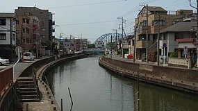
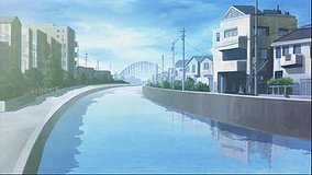
  • A quiet riverside view frames the railway bridge over the Kyū-Edogawa, emphasizing Zegapain’s reflective urban atmosphere.
  • This shot focuses on the bridge and riverside scenery over the Kyū-Edogawa rather than a close-up of any character, using an open composition to create the distinctive Zegapain feeling of reality and unreality blending together. As the story gradually reveals the truth of its world, the characters often pause in waterfront spaces like this to confront the gap between their memories, ordinary daily life, and battle. The moment functions like an emotional pause: before and after more intense developments, the calm water, bridge structure, and distant view express the characters’ unease and confusion while also conveying the series’ quiet sadness that everyday youth is beginning to fall apart. In real life, this is the Tokyo Metro Tozai Line’s First Edogawa Bridge, and the bridge outline, river width, and embankment lines remain very close to the anime, making the location highly recognizable. The anime simplifies some surrounding urban details to keep the bridge and water visually central, while the actual site includes more railings, revetment structures, road elements, and riverside buildings. Even so, viewing it from the riverbank path or nearby approaches still recreates the same broad lateral sense of space. There is no major official sign marking it as a Zegapain pilgrimage spot, so fans usually identify it by the bridge shape, railway line, and riverside terrain, and comparing the area with maps and Street View makes it easier to match the anime angle.
Where is the best public spot to view the Zegapain bridge scene?
The safest and easiest views are from the riverbank paths along the Kyū-Edogawa near the Tokyo Metro Tozai Line bridge. Do not enter railway property or restricted embankment areas.
Can I recreate the shot exactly with Google Street View first?
Yes, Street View and satellite maps are useful for matching the bridge angle and riverbank layout before you go. Exact framing may vary because the anime compresses some surrounding details.
Is there any official Zegapain marker or anime signage at the bridge?
No well-known official signboard for Zegapain is installed at this bridge, so fans identify it by the railway bridge shape and riverside geography. Bring the reference image and compare the embankment lines on site.

© 2026 Coser Map. All rights reserved.