cosermap logo
Local Weather
7-Day Forecast
Show Local Weather
Loading...

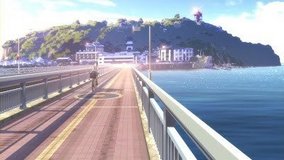
tsuritama natsuki running

Tsuritama

Tokyo

Episode
Ep. -
Time
-
No image available
  • Nearest Station: Katase-Enoshima Station (Odakyu Enoshima Line)
  • Walk: 15 minutes on foot
  • Best time to visit: Late morning to early afternoon in summer for bright light similar to the anime
  • Crowd level: Moderate
  • Natsuki runs through the street in an emotional outburst, shouting as he releases his bottled-up feelings.
  • This moment captures Natsuki in the middle of an emotional outburst, running forward while shouting as he releases the anxiety, loneliness, and frustration he has kept bottled up for so long. For a boy who usually hides his feelings, this is more than just a sprint through town; it marks a turning point where he finally begins to face both himself and the people around him. Before this scene, he is still guarded and defensive, but afterward he slowly grows closer to his friends and starts to change from within. The real-life counterpart is a sloped residential streetscape around Enoshima, and the anime reproduces the road layout, elevation changes, and corner views with impressive accuracy, creating the same sense of speed and summer air seen in the episode. The main differences today are small real-world details such as overhead wires, road markings, guardrails, and changes to house facades or plants over time. As a pilgrimage spot, the atmosphere still feels very close to the series, but visitors should note that this is an ordinary neighborhood street with no dedicated anime signs or official display boards, so it is best matched by comparing the slope, street composition, and overall perspective.
Is this Tsuritama running scene on a public residential street?
Yes. It is a normal neighborhood street near Enoshima, so visitors should keep noise low, avoid blocking the road, and be respectful when taking photos.
Are there any official Tsuritama signs or markers at this location?
No dedicated marker is typically installed here. Fans usually identify the spot by the slope, street layout, and surrounding houses rather than by official signage.
What is the best way to match the anime angle here?
Use Google Street View first to confirm the road curve and elevation, then visit in clear daylight when shadows are shorter and the street perspective is easier to compare.

© 2026 Coser Map. All rights reserved.