cosermap logo
Local Weather
7-Day Forecast
Show Local Weather
Loading...

the summit of the gods national route 15 sign

The Summit of the Gods

Tokyo

Episode
Ep. -
Time
-
the summit of the gods national route 15 sign
  • Nearest Station: Hamamatsucho Station (JR Yamanote Line / Keihin-Tohoku Line) or Daimon Station (Toei Asakusa Line / Oedo Line)
  • Walk: 8 minutes on foot
  • Best time to visit: Late morning or early afternoon on a clear day for easier road-sign matching and brighter street visibility
  • Crowd level: Moderate
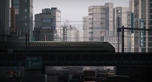
  • A quiet Tokyo street frame centers on the National Route 15 road sign, emphasizing the film's grounded urban realism.
  • This moment does not focus on character expressions, but instead uses a city street, road space, and signage to show the characters' movement and to reinforce the story's grounding in the real Tokyo cityscape. In The Summit of the Gods, as the protagonist pursues clues related to Jōji Habu and a photographic mystery, he frequently moves between the modern city and memories tied to the mountains; shots like this work as a breathing space in the narrative, letting viewers feel that he is steadily approaching the heart of the mystery in the real world. The emotional tone here is calm and restrained, with a slight sense of unease and determination, as if fate is quietly advancing even on an ordinary street. The real-life match is a National Route 15 guide sign in the Minato area of Tokyo, and the composition is recreated with impressive accuracy. The film closely captures the scale of the urban road beneath the elevated structure, the lane layout, and the placement of the blue route sign, showing a deliberate effort to preserve real streetscape features. The anime's rendering of the sign shape, road perspective, and central Tokyo traffic atmosphere is highly faithful, though some fine details may differ today because of changes in road equipment, ads, and nearby buildings over time. Overall, this is not a heavily dramatized sightseeing spot but a near-documentary urban reference point, making it especially rewarding to compare with Google Street View and on-site photos.
Can I safely photograph the National Route 15 sign from the anime spot?
Yes, but stay on the sidewalk and avoid stepping into the roadway or blocking pedestrian flow. This is an active city street, so handheld photos from public space are the safest option.
Is the scene still easy to compare with Google Street View today?
Yes, the road alignment, elevated structure, and sign position remain identifiable, though small details like nearby ads and street fixtures may have changed. Street View is very useful here because the scene depends on road geometry more than storefront details.
Are there useful facilities nearby for anime pilgrims visiting this location?
Yes, the area around Hamamatsucho and Daimon has convenience stores, cafes, and restrooms inside or near the stations. It is easy to combine this stop with a wider Tokyo pilgrimage route because public transport access is excellent.

© 2026 Coser Map. All rights reserved.