cosermap logo
Local Weather
7-Day Forecast
Show Local Weather
Loading...

the disappearance of nagato yuki chan school route cosmo oil kurakuen ss to myoban bridge

The Disappearance of Nagato Yuki-chan

Kyoto

Episode
Ep. -
Time
-
No image available
  • Nearest Station: Kōrakuen-guchi / Kurakuenguchi Station on the Hankyu Kōbe Line
  • Walk: 15–20 minutes on foot
  • Best time to visit: Morning on a clear weekday, especially in spring or early autumn for a school-route feel
  • Crowd level: Usually quiet
  • A quiet school-route street scene captures the gentle everyday atmosphere of The Disappearance of Nagato Yuki-chan.
  • This scene represents one of the anime’s typical everyday school-route moments, with a calm and quiet atmosphere touched by youthful warmth. When the characters pass along this road on the way to school, the story usually focuses not on dramatic conflict but on casual conversation, brief silences, and the comfort of simply being together. In situations involving Yuki Nagato, Kyon, Asakura, or the others, scenes like this often highlight the subtle distance and growing feelings between them. It can serve either as gentle setup for daily interactions or as the calm before an emotional shift, giving the moment a soft, restrained, and slightly nostalgic tone. In real life, this school route in the Kurakuen area, running from Cosmo Oil Kurakuen SS toward Myoban Bridge, matches the anime quite well in its road alignment, sense of slope, residential surroundings, and roadside railings, making the live-action source easy to recognize. The most noticeable points when comparing it with the anime are the curve of the road, the bridge railings, the width of the street, and the mix of low-rise homes and greenery. The anime simplifies some elements such as signage, overhead wires, parking areas, and storefront details, so the real gas station branding, road markings, and building facades look busier and more realistic on site. Seasonal changes, weather, and time of day also affect the density of the trees and the direction of light. Even so, as an anime pilgrimage spot, this is a highly identifiable stretch of road with a satisfying level of accuracy, especially for fans comparing it carefully with maps and Street View.
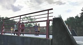
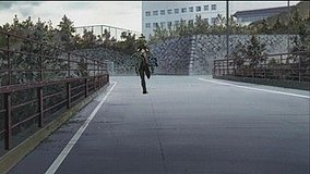
Is this road easy to match with the anime frame in person?
Yes. The curve of the road, bridge area, and residential layout make it one of the easier Nagato Yuki-chan school-route spots to compare with Street View and on-site photos.
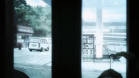
Can I take photos freely near the Cosmo Oil and Myoban Bridge area?
You can photograph the public street and bridge from public space, but avoid shooting directly into private homes or obstructing the gas station entrance. Be especially careful during commuting hours.
What is the best way to visit this location as part of a larger pilgrimage trip?
Most fans pair it with other Nishinomiya-area Haruhi and Nagato Yuki-chan locations, starting from Hankyu stations and walking between spots. Using Google Maps and Street View beforehand helps a lot because the scene is spread across a route rather than a single landmark.

© 2026 Coser Map. All rights reserved.