cosermap logo
Local Weather
7-Day Forecast
Show Local Weather
Loading...

suzume shuto expressway inner loop line

Suzume

Tokyo

Episode
Ep. -
Time
82m 52s
suzume shuto expressway inner loop line
  • Nearest Station: Tokyo Station (JR Yamanote Line, Chuo Line, Keihin-Tohoku Line, Marunouchi Subway nearby)
  • Walk: 8 minutes on foot
  • Best time to visit: Early morning or late afternoon for lighter traffic and clearer scene matching
  • Crowd level: Can be crowded
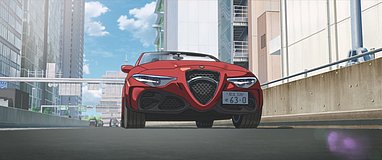
  • Suzume and Souta move through central Tokyo near the Shuto Expressway as the city rushes around them during a tense pursuit.
  • This moment appears during the tense Tokyo pursuit section of the story, when Suzume and Souta race through expressways and dense central traffic to catch Daijin and stop the disaster from spreading. Both are under intense pressure: Suzume is anxious and afraid, yet increasingly determined to protect Souta, while Souta bears the weight of both his physical condition and his duty as he guides her forward. The scene condenses the speed and oppressive atmosphere unique to the Tokyo chapter, while also showing how their trust becomes clearer amid the chaos. In real life, the scene is based on the area around the Shuto Expressway Inner Loop Line near Tokyo Station, and the film captures the elevated roads, curving ramps, and tightly packed urban buildings with impressive accuracy. The road structure, guardrails, and surrounding office blocks closely resemble the real setting, especially for visitors familiar with the Marunouchi and Yaesu expressway network. That said, the anime slightly heightens the sense of confinement and depth for dramatic effect. On location, some matching angles can be harder to reproduce because of elevated structures, traffic, and safety barriers, and certain signs or lane markers may have changed over time. Overall, it is a highly faithful urban road reference, lightly adjusted to strengthen the cinematic tension.
Can I recreate the Suzume shot from the Shuto Expressway itself?
No, pedestrians cannot enter the expressway. Fans usually photograph the area from nearby public streets and sidewalks around Tokyo Station where the elevated structure is visible.
What is the best nearby area to compare this scene with real life?
The streets around Tokyo Station’s Yaesu and Marunouchi sides give the best public views of the Inner Loop elevated roads. Google Street View is very helpful before visiting because road angles are limited on foot.
Are there any photography restrictions around this location?
Photos from public sidewalks are generally fine, but tripods can be obstructive in busy business districts and near station exits. Avoid blocking pedestrians and do not stop in roadway-adjacent areas for safety reasons.

© 2026 Coser Map. All rights reserved.