cosermap logo
Local Weather
7-Day Forecast
Show Local Weather
Loading...

summer time rendering tanohara settlement overview

Summer Time Rendering

Kobe

Episode
Ep. -
Time
-
summer time rendering tanohara settlement overview
  • Nearest Station: Kada Station (Nankai Kada Line)
  • Walk: 25–35 minutes on foot, depending on your exact viewpoint route
  • Best time to visit: Late afternoon on a clear day for a similar elevated light and settlement atmosphere
  • Crowd level: Usually quiet
  • A distant elevated view captures the quiet coastal settlement that serves as one of Summer Time Rendering’s deceptively peaceful yet unsettling backdrops.
  • This moment looks down over the Tanohara settlement without focusing on any specific character, using a quiet yet uneasy atmosphere to establish the overall setting of Hitogashima in Summer Time Rendering. The series often uses wide views like this to let viewers feel the island’s enclosed, tightly connected community before major incidents erupt. Around scenes like this, Shinpei is usually investigating the island’s strange events, so even when the landscape appears peaceful, the emotional undercurrent is tense, suspicious, and fatalistic. In real life, this spot in the Kada area of Wakayama closely matches the anime’s elevated overview, especially in the terrain, clustered houses, and general composition. The anime simplifies elements such as utility lines, vegetation, and building details for a cleaner image, while the real view changes with the season, weather, and plant growth. There is typically no obvious anime location sign here, so fans usually compare the slope, road layout, and house arrangement, often with maps or Street View, to appreciate how the real settlement was transformed into one of the series’ calm but ominous backdrops.
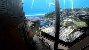
Is this Tanohara overview spot easy to reach from Kada Station?
It is reachable on foot from Nankai Kada Station, but the route includes uphill residential roads, so comfortable shoes and mobile navigation are recommended.
Are there official Summer Time Rendering signs at this viewpoint?
Fans generally report that this overlook itself is identified more by matching the landscape than by a large dedicated scene marker, so use maps and comparison images before you go.
Can I take photos freely at the settlement overview location?
You can usually photograph the scenery from public roads, but this is a lived-in residential area, so avoid blocking traffic, entering private land, or aiming cameras into homes.

© 2026 Coser Map. All rights reserved.