cosermap logo
Local Weather
7-Day Forecast
Show Local Weather
Loading...

sound euphonium hadoyama ryokuchi park

Sound! Euphonium

Osaka

Episode
Ep. 12
Time
20m 59s
sound euphonium hadoyama ryokuchi park
  • Nearest Station: JR Uji Station (Nara Line) or Keihan Uji Station (Keihan Uji Line)
  • Walk: About 20–30 minutes on foot, depending on approach route
  • Best time to visit: Late afternoon in spring or early summer for soft light and greenery similar to the anime
  • Crowd level: Usually quiet
  • Kumiko and Reina walk side by side along a quiet sloped road near Hadoyama Ryokuchi Park in a reflective moment from Sound! Euphonium.
  • This moment appears during an important stretch when the relationship between Kumiko and Reina grows noticeably closer. As they walk along a quiet slope near a residential area, their conversation continues the emotionally revealing exchanges surrounding the band’s pressure and competition arc. Kumiko comes to understand Reina’s resolve more deeply, while Reina shows a more vulnerable side that she rarely reveals in everyday club life. The mood here is not dramatic conflict, but a calm and intimate exchange filled with youthful tension and emotional closeness, naturally deepening their bond and setting up later mutual recognition. In real life, the road near Hadoyama Ryokuchi Park matches the anime composition quite well, especially the incline, the greenery, and the edge between the residential zone and the roadside. The anime version simplifies the background and removes some everyday urban clutter, so visitors may notice more power lines, guardrails, signs, and small landscaping differences on site. When compared with the actual location and Street View, the road alignment and slope are highly recognizable, though tree growth, seasonal colors, and posted notices may have changed over time. Overall, it is a highly identifiable Sound! Euphonium pilgrimage spot, best visited quietly and respectfully because it sits within a residential environment.
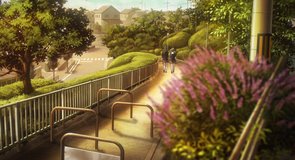
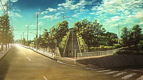
Is this Sound! Euphonium slope easy to recognize in person?
Yes. The uphill road shape and the residential-greenbelt boundary are still recognizable, though trees, signs, and small roadside details may differ from the anime frame.
Can I take photos here without any special permission?
Yes, casual photography from public roads is generally fine, but this is near a residential area, so avoid blocking traffic, entering private property, or photographing homes directly.
Is there a good way to match the anime angle before visiting?
Yes. Checking Google Street View in advance helps a lot here because the slope and curve are easier to align on screen than by memory once you arrive.

© 2026 Coser Map. All rights reserved.