cosermap logo
Local Weather
7-Day Forecast
Show Local Weather
Loading...

sakaagari hurricane irohazaka street

Sakaagari Hurricane

Tokyo

Episode
Ep. -
Time
-
sakaagari hurricane irohazaka street
  • Nearest Station: Keio-Yomiuriland Station (Keio Sagamihara Line)
  • Walk: 12 minutes on foot
  • Best time to visit: Late morning or early afternoon on a clear day for lighting similar to residential daytime scenes
  • Crowd level: Usually quiet
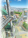
  • A quiet residential street view captures the ordinary everyday atmosphere used as a transition scene in Sakaagari Hurricane.
  • This moment does not focus on a character close-up, but instead uses an empty street view to connect the rhythm of the story and create the feeling of everyday movement as the characters go back and forth and their relationships slowly progress. The mood is calm and slightly expectant, as if the familiar school route and residential neighborhood are giving the viewer a brief emotional pause before an important conversation or shift in feelings. Around this point in the story, the series naturally links subtle romantic tension, light school-life energy, and the small stirrings of romantic comedy. The real-life location is Irohazaka Street in Tokyo, and the anime recreates the slope of the road, the housing layout on both sides, and the long street perspective with impressive accuracy. While the anime simplifies utility lines, roadside details, and some building exteriors to make the frame cleaner and brighter, the overall street outline and viewing angle remain very close to the actual spot. Compared with the real location, signs and house identifiers are mostly toned down or omitted in the anime, likely to avoid excessive realism and protect privacy, while real-world street views from different years may show slight changes in greenery, parked cars, wall colors, and road markings. Overall, this is a pilgrimage spot where the atmosphere matches extremely well even if the fine details are polished, making it ideal for recreating the scene by comparing the slope and road width on Google Street View.
Is this Sakaagari Hurricane spot easy to photograph today?
Yes, the street is publicly accessible, but it is a normal residential road, so keep clear of driveways and avoid blocking traffic while shooting.
Can I match the anime angle closely using Google Street View first?
Yes. Street View is very useful here because the slope, road width, and house alignment are the key matching points for this scene.
Are there any special pilgrimage signs or official anime markers at Irohazaka Street?
No official anime monument is known at this specific spot. Fans usually identify it by the road shape and surrounding residential layout rather than dedicated signage.

© 2026 Coser Map. All rights reserved.