cosermap logo
Local Weather
7-Day Forecast
Show Local Weather
Loading...

my dress up darling seibu ikebukuro line elevated crossing intersection

My Dress-Up Darling

Tokyo

Episode
Ep. 3
Time
18m 52s
my dress up darling seibu ikebukuro line elevated crossing intersection
  • Nearest Station: Shiinamachi Station (Seibu Ikebukuro Line)
  • Walk: 8 minutes on foot
  • Best time to visit: Late morning or early afternoon on a clear day for lighting similar to the anime’s everyday street atmosphere
  • Crowd level: Moderate
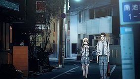
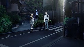
  • Gojo and Marin walk together at a street intersection beneath the Seibu Ikebukuro Line elevated tracks in Episode 3 of My Dress-Up Darling.
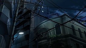
  • This moment appears as Wakana Gojo and Marin Kitagawa are becoming more comfortable with each other, moving from ordinary classmates into companions who can naturally spend time together and share interests. Marin is as bright and forward as ever, showing her excitement and curiosity openly, while Gojo still seems a little reserved but is slowly letting his guard down around her. The street scene captures a simple everyday moment of the two walking together, with a relaxed and lived-in atmosphere that highlights how their bond is growing during the cosplay preparations. The emotions around this point are not dramatic; instead, it feels like one of those important transitional scenes in a youth story that seems ordinary on the surface but makes the relationship feel more genuine. The real location is based on the intersection near the Seibu Ikebukuro Line elevated tracks, and the anime recreates the overall street composition with impressive accuracy. The elevated railway structure, the direction of the roads, and the open yet residential feel of the intersection all match the real place well. In real life, the traffic signs, guardrails, road markings, and utility poles are usually more cluttered, while the anime simplifies and cleans up those details but keeps the core visual markers that make the spot recognizable. Compared with the anime, the real signage is busier and some surrounding buildings may have changed over time, so a Google Street View or on-site comparison shows that it is not a perfect one-to-one copy but a realistic rearrangement. Even so, the elevated tracks, the intersection angle, and the scale of the neighborhood are portrayed very faithfully, making it easy for fans to feel the same everyday atmosphere from the series during a pilgrimage visit.
Is this My Dress-Up Darling street spot easy to photograph from the sidewalk?
Yes. It is a public street intersection, so you can photograph it from the sidewalk, but stay clear of crossings, traffic, and private residential entrances.
What is the best way to match the anime angle at this elevated crossing?
Use Google Street View first to line up the road direction and the Seibu Ikebukuro Line overpass, then adjust your position near the intersection corners on site for the closest match.
Are there useful facilities nearby for a quick anime pilgrimage stop?
Yes. The area around Shiinamachi Station has convenience stores, cafés, and restrooms in or near the station, making it practical for a short visit.

© 2026 Coser Map. All rights reserved.