cosermap logo
Local Weather
7-Day Forecast
Show Local Weather
Loading...

my deer friend nokotan tama kyry prefectural natural park

My Deer Friend Nokotan

Tokyo

Episode
Ep. 11
Time
20m 8s
my deer friend nokotan tama kyry prefectural natural park
  • Nearest Station: Odakyu-Tama-Center Station (Odakyu Tama Line / Keio Sagamihara Line) or Tama-Center Station area bus connections
  • Walk: About 25–35 minutes on foot depending on the exact approach, or shorter by local bus
  • Best time to visit: Late morning to afternoon in clear weather, especially spring or early autumn for greenery similar to the anime
  • Crowd level: Usually quiet
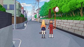
  • Nokotan and Koshi Torako are shown along a quiet roadside near the Tama Hills natural park area during a calm transitional moment.
  • This moment appears during the characters’ movement from place to place, and the focus is less on a major event than on the everyday pacing that builds My Deer Friend Nokotan’s signature offbeat humor. Nokotan turns even an ordinary roadside into something absurd and funny through her unpredictable behavior, while Koshi Torako follows along with a mix of exasperation and familiarity. The mood here is light and relaxed, almost like a short pause before the next gag lands, and the surrounding scene helps emphasize the duo’s contrasting but well-established chemistry. In real life, this spot is near the Tama Hills Natural Park area, and the anime captures the road alignment, greenery, and open suburban atmosphere quite well. The background art appears to simplify some practical details such as guardrails, shoulder width, utility poles, and the exact placement of signs, so visitors will notice that the real street looks more functional and cluttered than the cleaner anime frame. Even so, the adaptation preserves the most recognizable features, especially the gentle terrain, road shape, and wooded edges, making it a highly identifiable location with slight visual simplification.
Is this Nokotan spot easy to recreate on foot from Tama-Center?
Yes, but it is more comfortable if you combine the station with a local bus because the natural park area has longer roadside stretches and some elevation changes.
Can I use Google Street View to match the roadside angle from the anime?
Yes, Street View is useful here because the road shape and tree lines are more reliable matching points than small background details that the anime simplified.
Are there facilities or convenience stops near the park-side road?
Facilities are limited once you get closer to the quieter roadside sections, so it is best to prepare drinks, sunscreen, and route checks before leaving the station area.

© 2026 Coser Map. All rights reserved.