cosermap logo
Local Weather
7-Day Forecast
Show Local Weather
Loading...

love chunibyo other delusions heart throb kansai electric power substation tower

Love, Chunibyo & Other Delusions - Heart Throb -

Osaka

Episode
Ep. 10
Time
16m 54s
love chunibyo other delusions heart throb kansai electric power substation tower
  • Nearest Station: Zeze Station (JR Biwako Line / Keihan Ishiyama-Sakamoto Line area)
  • Walk: 20–25 minutes on foot
  • Best time to visit: Late afternoon on a clear day for lighting similar to the anime and easier landmark matching
  • Crowd level: Usually quiet
  • Rikka and Yuta walk along a quiet roadside near the transmission tower, framed by open sky and utility infrastructure.
  • This moment appears during a stretch of the story when the relationship between the characters becomes increasingly delicate and emotionally charged. Rikka and Yuta are walking along the edge of a residential area and a more open roadside space, and unlike their usual playful mood, the atmosphere here feels quiet, hesitant, and subdued. Even though they are still walking side by side, both are carrying thoughts they have not yet voiced, which gives the scene a noticeable stillness. The frame captures a pause in their emotional transition: they are moving forward physically while also trying to understand a new distance between them. The surrounding story before and after this scene centers on how they face love, growth, and reality, which makes this simple road and back-view composition feel especially meaningful. In real life, the scene is recreated with impressive accuracy in terms of the road alignment, the transmission tower placement, and the open feeling of the area, especially the strong visual presence of the west tower by the Kansai Electric Power Zeze Substation. The anime simplifies the background slightly, making the power lines, guardrails, and roadside elements appear cleaner and more orderly, while the real location has denser vegetation and more complex infrastructure details. This is not a tourism-focused landmark, so there are almost no obvious signs or anime pilgrimage guides on site, and visitors usually identify it by matching the tower, road angle, and surrounding streetscape. If you compare it through Google Street View, the overall composition is very close to the anime, though seasonal changes, weather, and roadside updates create some small visual differences.
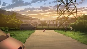
Can I stand right next to the tower to recreate the shot?
No, the tower and substation facilities are utility property, so fans should stay on public roads and sidewalks. The best match comes from roadside angles rather than entering restricted land.
Is there any official anime sign or pilgrimage marker here?
There is no widely reported official Chunibyo signboard or marker at this exact spot. Most visitors identify it by the tower, road shape, and map or Street View comparison.
What is the easiest way to compare the scene on site?
Use Google Maps or Street View with the tower and roadside alignment as your main reference points. Visiting in clear weather helps because utility lines and the skyline are easier to match with the anime frame.

© 2026 Coser Map. All rights reserved.