cosermap logo
Local Weather
7-Day Forecast
Show Local Weather
Loading...

kemurikusa nakajima toll station

kemurikusa.

Kyoto

Episode
Ep. 5
Time
8m 42s
kemurikusa nakajima toll station
  • Nearest Station: JR Yumesaki Line Ajikawaguchi Station
  • Walk: about 35–45 minutes on foot
  • Best time to visit: Late morning or afternoon on a clear day for safer visibility and easier road comparison
  • Crowd level: Usually quiet
  • Rin, Ritsu, and Wakaba stand on a deserted roadway modeled after Nakajima Toll Station, surrounded by broad lanes and urban expressway infrastructure.
  • In this moment, Rin and her companions continue traveling through the abandoned city shrouded in red mist, arriving at an area around a toll-gate-like expressway facility. Faced with a silent and unfamiliar man-made structure, they stay alert for danger while searching for clues about where to go next. Rin keeps her usual calm but tense focus, Ritsu looks thoughtful and observant, and Wakaba continues learning about the remnants of this broken world. Rather than being a dramatic climax, this is an important transitional scene filled with unease and exploration that sets up the group’s later movement and discoveries. The scene is clearly based on Nakajima Toll Station in Osaka, and the anime captures the wide roadway, the strongly divided traffic layout, and the industrial expressway atmosphere created by elevated roads and ramps. However, it does not copy the real site exactly; instead, it simplifies the road structure and removes much of the modern traffic information to better fit Kemurikusa’s lonely post-apocalyptic visual style. Compared with the actual location, the real toll area has denser signage, toll equipment, guardrails, and lane markings, while the anime keeps the outline and spatial feeling but reduces text and color to make the space feel emptier and more desolate. When visiting, fans can still identify the inspiration quite clearly through Google Street View by comparing the lane width, toll gate arrangement, and surrounding elevated-road scenery.
Can I safely recreate the Kemurikusa shot at Nakajima Toll Station?
You can visit the surrounding public roads and sidewalks, but the toll facility itself is a live traffic area, so avoid entering restricted zones or standing near vehicle lanes for photos.
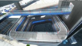
Is Google Street View useful for matching this Episode 5 scene?
Yes. Street View is one of the best ways to compare the lane layout, overhead structures, and toll-gate spacing before you go, since some angles are hard to access on foot.
Are there convenience stores or rest spots near this pilgrimage location?
Facilities are limited around the toll-road area, so it is best to bring drinks and check nearby shops in advance around Ajikawaguchi or other station areas before walking over.

© 2026 Coser Map. All rights reserved.