cosermap logo
Local Weather
7-Day Forecast
Show Local Weather
Loading...

k on matsugasaki bridge

K-ON!

Osaka

Episode
Ep. 3
Time
3m 42s
k on matsugasaki bridge
  • Nearest Station: Matsugasaki Station (Kyoto Municipal Subway Karasuma Line)
  • Walk: about 10 minutes on foot
  • Best time to visit: Late afternoon on a clear day, especially in spring or autumn
  • Crowd level: Usually quiet
  • Yui Hirasawa is shown in a calm everyday moment near Matsugasaki Bridge, capturing K-ON!'s gentle after-school atmosphere.
  • This moment appears during one of the series’ everyday transition scenes, focusing less on dramatic plot and more on the relaxed rhythm of after-school life that defines K-ON!. The character is shown in a natural, easygoing mood near the bridge, capturing one of those small but precious moments of youth. Scenes like this usually carry the lingering warmth of club activities or conversations with friends and gently lead into the next part of the school-day routine. In real life, Matsugasaki Bridge in Kyoto’s Sakyo area spans the Takano River, and the bridge deck, railings, and open riverside view match the anime composition quite closely, making it an easily recognizable pilgrimage spot. The anime simplifies some background details, so the road, barriers, and distant scenery look cleaner, but the bridge lines, spacious river atmosphere, and surrounding residential feel are reproduced very accurately. On site, signs, traffic fixtures, and newer urban elements stand out more than in the anime, which is a typical difference between animation and reality. Even so, a comparison with the actual site or Google Street View clearly shows how faithfully the landscape was adapted, making it a rewarding stop for fans planning a visit.
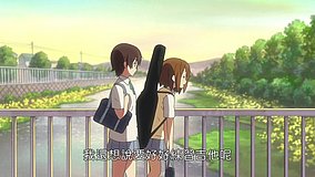
Is Matsugasaki Bridge easy to access for a K-ON! pilgrimage stop?
Yes. It is reachable on foot from Matsugasaki Station on the Kyoto Municipal Subway Karasuma Line, and the riverside area is open and easy to approach.
Can I take photos on the bridge and by the riverbank?
Yes, casual photography from public walkways is generally fine, but do not block pedestrians, cyclists, or traffic on the bridge. Be respectful of nearby homes and avoid loud group activity.
What is the best way to compare the anime angle with the real location?
Use Google Street View and river-side map references before visiting, then align the bridge railing and Takano River background on site. Afternoon light usually makes the comparison easier and closer to the anime atmosphere.

© 2026 Coser Map. All rights reserved.