cosermap logo
Local Weather
7-Day Forecast
Show Local Weather
Loading...

joshiraku city hall center front

Joshiraku

Tokyo

Episode
Ep. 11
Time
10m 56s
joshiraku city hall center front
  • Nearest Station: Seibu Tamagawa Line, Shin-Koganei Station
  • Walk: 18 minutes on foot
  • Best time to visit: Late morning or early afternoon on a clear day for matching street visibility
  • Crowd level: Usually quiet
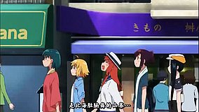
  • A street-side shot captures the characters passing the area in front of the city center amid an ordinary suburban streetscape.
  • This moment appears while the characters are out moving through town, and instead of feeling especially noisy, it carries the relaxed mood of an everyday walk. As they continue chatting, the series keeps its usual rhythm of banter and playful teasing, creating an atmosphere that sits between easygoing and lightly sarcastic. The shot is not a major dramatic turning point, but it uses the streetscape and the characters’ conversation to build the distinctive slice-of-life tempo of Joshiraku, letting viewers enjoy their natural chemistry against an ordinary background before the episode flows back into its exaggerated yet familiar talkative style. The real-world match is the road space around 市政センター前, and the anime reproduces the overall street alignment, road width, and spacing of nearby buildings quite accurately, making it a location that fans can recognize at a glance. In real life, the easiest clues are the stop area, roadside facilities, and the civic neighborhood atmosphere, while the anime keeps those structural features but simplifies some signage and smaller details for a cleaner frame. Compared with the actual site, vegetation, pavement markings, and posted notices may have changed over time, so using Street View to compare intersection angles, sign placement, and building outlines makes it much easier to confirm the exact spot.
Is the 市政センター前 Joshiraku spot easy to photograph without blocking traffic?
Yes, it is a roadside public area, but stay on the sidewalk and avoid standing near bus operations or crossing points. Quick handheld shots are the safest option.
What is the best way to confirm the exact angle from the anime frame here?
Use Google Street View first and match the road curve, sign positions, and building spacing before visiting. The scene works best when you align yourself with the street frontage rather than the middle of the road.
Are there useful facilities nearby for fans doing a short pilgrimage stop?
Yes, the area around the civic center has basic neighborhood facilities such as bus access, public buildings, and convenience options within walking distance. It is best visited as part of a wider Koganei-area location hunt.


© 2026 Coser Map. All rights reserved.