cosermap logo
Local Weather
7-Day Forecast
Show Local Weather
Loading...

flower and asura daimonjiyama hiking trail

Flower and Asura

Osaka

Episode
Ep. -
Time
-
flower and asura daimonjiyama hiking trail
  • Nearest Station: Keage Station (Kyoto Municipal Subway Tozai Line)
  • Walk: 25–35 minutes on foot
  • Best time to visit: Late morning to afternoon in clear weather, especially spring or autumn
  • Crowd level: Moderate
  • A quiet mountain trail frame captures a transitional moment in Flower and Asura, emphasizing atmosphere over action.
  • This moment appears during a stretch when the characters are on the move, and the focus is not on dramatic action but on the calm atmosphere created by the mountain trail itself. As they continue forward in the surrounding scenes, they are also sorting out their thoughts and feelings, so this frame carries the sense of a brief emotional pause. The natural setting makes everything feel restrained and introspective, mixing the hesitation and unease typical of a youth story with a subtle determination about what comes next. In real life, the anime recreates the terrain and atmosphere around the Daimonjiyama Hiking Trail quite well, especially the sense of slope, the vegetation closing in on both sides, and the open feeling of a path leading into the mountain. The anime simplifies fine details, so trail signs, warning boards, surface materials, and the exact condition of the trees may differ on site, and the overall colors also change with the season, weather, and maintenance. As an anime pilgrimage spot, this is a location that stands out more for its landform and mood than for one exact landmark, and even if every sign is not identical, the overall outline and hiking-trail atmosphere remain highly recognizable.
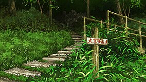
Which access point is best for recreating this Flower and Asura trail scene?
Most fans start from the Ginkaku-ji side of the Daimonjiyama Hiking Trail, as it is the most common and straightforward access route. Keage is a useful rail stop, but expect extra walking or a bus/taxi connection depending on your chosen trailhead.
Can I use Google Street View to match this anime location exactly?
Only partially. Street View coverage is limited on mountain approaches, so fans usually compare the lower access roads on Street View and then match the trail itself by slope, vegetation, and path alignment.
Are there any visitor rules or safety tips for photographing on the trail?
Yes—stay on the marked path, avoid blocking hikers, and do not use drones in a way that disturbs others or violates local rules. Wear proper shoes and bring water, because this is a real hiking route rather than an urban photo spot.

© 2026 Coser Map. All rights reserved.