cosermap logo
Local Weather
7-Day Forecast
Show Local Weather
Loading...

digimon adventure sky walkway

Digimon Adventure

Tokyo

Episode
Ep. -
Time
-
digimon adventure sky walkway
  • Nearest Station: Shin-Toyosu Station (Yurikamome Line)
  • Walk: 12 minutes on foot
  • Best time to visit: Late afternoon on a clear day for matching shadows and a calmer urban atmosphere
  • Crowd level: Moderate
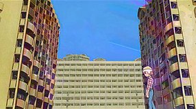
  • A quiet urban sky walkway and road junction are shown, creating an empty, reflective city atmosphere in Digimon Adventure.
  • This shot does not focus on a character but instead uses the sky walkway and surrounding city streets to create a quiet atmosphere with a hint of unease. In Digimon Adventure, this kind of empty urban view often appears around moments when the children are about to face a new development, split up, or move between ordinary city life and a sense of something strange. The bridge and roadway give the feeling of a brief pause away from the noise, a moment of reflection and observation that strengthens the series’ familiar yet slightly uncanny urban mood. In real life, the location matches the anime quite well in the road alignment, the structure of the walkway, and the overall elevation changes, showing that the scene was clearly based on an actual city space and then simplified for animation. The anime omits many small real-world details such as traffic signs, railing textures, nearby facilities, and commercial signage, making the frame cleaner and more focused on mood, while the actual site shows changes from different years, including updated notices, planting, and building exteriors. If you stand near the original angle, the relationship between the walkway and the surrounding roads is still easy to recognize, making this one of the more convincing and enjoyable Digimon Adventure pilgrimage spots.
Can I freely photograph the Digimon Adventure sky walkway angle here?
Yes, you can usually take photos from public sidewalks and pedestrian areas, but avoid blocking foot traffic and do not use tripods during busy periods.
Is the walkway itself still accessible to visitors?
The surrounding pedestrian route is generally accessible, but temporary construction or maintenance can affect exact access, so check local map updates before visiting.
What is the best way to compare the anime shot with the real location before going?
Use Google Street View and overhead maps to confirm the road layout and bridge angle in advance, since small urban changes can affect the exact framing.

© 2026 Coser Map. All rights reserved.