cosermap logo
Local Weather
7-Day Forecast
Show Local Weather
Loading...

clannad sakura slope

Clannad

Tokyo

Episode
Ep. 10
Time
9m 22s
clannad sakura slope
  • Nearest Station: Numabe Station (Tokyu Tamagawa Line)
  • Walk: 12 minutes on foot
  • Best time to visit: Late afternoon in spring or early autumn for soft light and a similar residential atmosphere
  • Crowd level: Usually quiet
  • Tomoya and Nagisa stand together on the sloping residential street, framed by the gentle rise of the road and neighborhood buildings.
  • This moment shows Tomoya and Nagisa walking together on a familiar slope, at a point in the story when their relationship has become more natural and emotionally open. Around episode 10, the plot centers on Nagisa gradually regaining confidence, working toward the drama club, and Tomoya steadily becoming someone she can rely on. There is no major confrontation here, but the scene carries Clannad’s signature warmth of everyday life: Tomoya sounds casual on the surface, yet he is clearly looking out for Nagisa, while Nagisa shows a sense of relief and shy comfort in his presence. The road functions not only as part of their after-school routine, but also as a symbol of how their bond is slowly moving forward. In real life, this sloping street matches the anime composition quite well, especially in the incline of the road, the narrow residential feel, and the arrangement of the surrounding neighborhood. The anime is highly accurate in reproducing the overall terrain, though some details are simplified, and building exteriors, utility poles, roadside signs, and vegetation may have changed over time. As an ordinary residential street, the site does not have prominent official anime signage or major pilgrimage markers, so fans usually recreate the scene by matching the slope, road width, and viewing angle. When compared with Google Street View, it becomes even clearer how Clannad transforms a real streetscape into a softer and more emotionally resonant background.
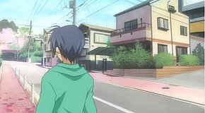
Is this Clannad slope an official anime pilgrimage spot?
No official marker is installed at the site; fans recognize it through location databases and scene-matching comparisons rather than formal tourism signage.
Can I take photos here freely?
Yes, but it is a normal residential street, so keep to public space, avoid blocking the road, and do not photograph private homes or residents up close.
What is the best way to confirm the exact shooting angle before visiting?
Use Google Street View and compare the road incline, wall lines, and house spacing in advance, since small neighborhood details have changed since the anime aired.

© 2026 Coser Map. All rights reserved.