cosermap logo
Local Weather
7-Day Forecast
Show Local Weather
Loading...

beyond the boundary road sign

Beyond the Boundary

Kyoto

Episode
Ep. 8
Time
-
beyond the boundary road sign
  • Nearest Station: Kintetsu-Haibara Station (Kintetsu Osaka Line)
  • Walk: About 35–45 minutes on foot, or shorter by local bus/taxi
  • Best time to visit: Late morning to afternoon on a clear day for safer roadside photography and lighting similar to the anime
  • Crowd level: Usually quiet
  • A transitional roadside shot focuses on a traffic sign and the surrounding street, underscoring the uneasy mood of Beyond the Boundary episode 8.
  • This shot does not show any characters directly, instead using a roadside sign and the surrounding road as a transition cut that builds the growing unease of episode 8. As the story advances, relationships and hidden truths steadily come to the surface, and the overall mood shifts from everyday lightness into pressure and caution. The moment works like a brief pause for the viewer, placed at the boundary before and after the characters’ movements, reinforcing the feeling that they are heading toward something unavoidable and deepening the sense of travel and fate crossing paths. In real life, the key match point is the road layout, shoulder width, guardrail placement, and the position of the sign, and the overall composition is quite close to the anime’s transitional shot. The anime presents the real road sign, slope, and roadside greenery in a relatively realistic way, so even without characters in frame, fans can recognize the location easily. When visiting, the sign text, paint condition, and surrounding tree height may differ depending on the year, and a comparison with Google Street View usually reveals small changes in detail, but the main terrain and road lines still match very well. Since this is essentially a roadside marker on a normal public road, it is best approached as a quick photo stop while staying careful not to interfere with traffic.
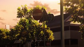
Is this Beyond the Boundary spot easy to recreate from public roads?
Yes, the scene is based on a roadside sign and road alignment visible from public space. Be careful because the shoulder is limited in places and traffic safety matters more than exact framing.
Can I rely on Google Street View to compare this location before visiting?
Yes, Street View is useful here because the road shape, guardrails, and sign placement are the main match points. Small details like vegetation and sign condition may differ from the anime or newer on-site views.
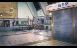
Are there shops or facilities right next to the scene location?
Not immediately at the sign itself, so bring drinks and check transport in advance. It is better treated as a brief stop during a wider Nara-area pilgrimage route rather than a standalone destination.

© 2026 Coser Map. All rights reserved.