cosermap logo
Local Weather
7-Day Forecast
Show Local Weather
Loading...

dyke

AIR

Kobe

Episode
Ep. -
Time
-
dyke
  • Nearest Station: Kasumi Station (JR Sanin Main Line)
  • Walk: About 30 minutes on foot
  • Best time to visit: Late afternoon in clear weather, especially summer to early autumn
  • Crowd level: Usually quiet
  • Yukito and Misuzu stand by the coastal dyke under an open sky, sharing a quiet moment filled with distance and tenderness.
  • This moment comes during a calmer stretch of the story, when Yukito Kunisaki and Misuzu Kamio spend time together near the seaside dyke. Even though they are physically close, the scene carries a quiet sense of loneliness and tenderness. Misuzu tries to keep her usual innocent and cheerful demeanor, but as they grow closer, her inner anxiety and isolation begin to show. Yukito, meanwhile, slowly shifts from being an observer to someone who genuinely wants to protect her. The moment feels like a brief pause in everyday life, with the sea breeze and open landscape stretching out the characters’ emotions and foreshadowing the deeper, more heartbreaking developments to come. In real life, this dyke in Kami, Hyogo closely matches the coastal composition seen in the anime, especially in the line of the embankment, the road, and the openness toward the sea. The anime simplifies some background details, reducing the presence of utility poles, railings, and other man-made features to create a cleaner and more summery atmosphere, while the real site feels more grounded and practical. It is not a major tourist landmark, so visitors should not expect obvious anime signage or official markers, and scene matching usually depends on comparing the terrain and viewing angle. When checked against street-level imagery or on-site photos, the overall topography and mood are reproduced quite faithfully, though vegetation, pavement texture, and barrier placement may differ due to time, weather, and later maintenance.
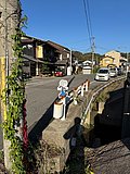
Is this AIR dyke scene easy to match on site?
Yes, the embankment line and open coastal view are still the main clues, but you will need to adjust for modern railings and road details. Comparing with online map imagery before visiting helps a lot.
Are there any official AIR signs or pilgrimage markers at the dyke?
No official anime signboard is generally reported at this exact spot. It is better approached as a quiet location match rather than a formally developed anime tourism site.
What should visitors keep in mind when taking photos here?
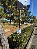
The dyke is part of an active coastal protection area, so avoid blocking roads or climbing barriers. Wind can be strong near the shore, so secure your gear and visit in daylight for safer angle matching.

© 2026 Coser Map. All rights reserved.