cosermap logo
Local Weather
7-Day Forecast
Show Local Weather
Loading...

upward view

TARI TARI

Tokyo

Episode
Ep. -
Time
-
No image available
  • Nearest Station: Katase-Enoshima Station (Odakyu Enoshima Line)
  • Walk: 15 minutes on foot
  • Best time to visit: Late morning to afternoon on a clear day for matching the bright upward-looking atmosphere
  • Crowd level: Moderate
  • An upward-looking shot captures the quiet skyward perspective often used in TARI TARI to emphasize pause, reflection, and youthful hope.
  • This upward-looking composition creates a calm pause, like a moment when the characters lift their eyes and quietly sort through their feelings after a conversation, worry, or emotional clash. TARI TARI often uses the coastal streets, slopes, and open sky around the Shonan and Enoshima area to reflect the inner lives of its teenage characters as they struggle with dreams, friendship, and growing up. In scenes like this, the emotions are usually not explosive, but gently mixed with uncertainty, warmth, and a small sense of hope. The feeling before and after this moment is often one of shifting between everyday life and youthful anxiety, showing that even if the characters are still under pressure, they are beginning to find the courage to move forward. In real life, this coordinate sits in the Enoshima area with the kind of sloping terrain and residential street atmosphere that matches TARI TARI very well. The anime tends to emphasize the sky, utility poles, edges of the road, and building lines, and if you shoot from a low angle on site, you can recreate a very similar visual rhythm. Because this type of location is usually based on ordinary public roads or residential surroundings, there may be no obvious anime signage or official marker, so it feels more like a hidden pilgrimage spot recognized by devoted fans. Compared with the anime, plants, signs, resurfaced pavement, parked vehicles, and wire layouts may have changed over time, but the slope and street direction still preserve strong visual identity. When checked alongside maps and Street View, the scene still shows how accurately TARI TARI captured the everyday look of Shonan.
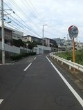
Is this upward-view TARI TARI spot on a public road?
Yes, the area around this coordinate is part of ordinary public streets near Enoshima, so you can photograph from public space. Please avoid blocking traffic and do not step onto private residential property.
Are there any official TARI TARI signs or markers here?
No official anime marker is generally associated with this exact upward-view point. Fans usually identify it by matching the road angle, skyline, and utility poles with screenshots and Street View.
What is the best way to recreate the anime angle at this location?
Use a low shooting position and tilt the camera upward to emphasize the sky, poles, and slope just like the anime. A clear day works best, since weather and parked cars can noticeably change the look of the street.

© 2026 Coser Map. All rights reserved.