cosermap logo
Local Weather
7-Day Forecast
Show Local Weather
Loading...
slope end
  • Nearest Station: Higashi-Ome Station (JR Ome Line)
  • Walk: about 20 minutes on foot
  • Best time to visit: Late afternoon on a clear day for lighting similar to the anime and a quiet neighborhood atmosphere
  • Crowd level: Usually quiet
  • Tomoya and Ushio share a quiet walk along the sloping residential street near the slope-end in CLANNAD 〜AFTER STORY〜 Episode 23.
  • This moment appears near the end of the story, as Tomoya and Ushio walk together through a familiar slope and neighborhood street. The frame feels deeply ordinary, yet it carries the weight of everything Tomoya has endured—loss, regret, and the quiet warmth of regaining family bonds. After so much pain, this calm walk becomes especially precious, compressing the series’ core theme of family into a single gentle instant. The emotions here are no longer only sorrow, but also understanding, gratitude, and a faint sense of hope, giving the audience the feeling that the story has finally returned to the warmth of everyday life. In real life, the slope-end location matches the anime quite closely: the road gradient, the openness of the turn, and the rhythm of the residential street are all strongly recognizable, and the atmosphere of a quiet neighborhood is very faithful to the series. The anime simplifies the background slightly, cleaning up utility lines, roadside fixtures, and some housing details, so the scene appears softer than the real place. If you compare it with Street View or visit in person, you can still clearly identify the same road alignment and elevation change, though signs, guardrails, road markings, and nearby buildings may have changed over time. Overall, it is a highly accurate location, but one best recognized by the shape of the slope and the outline of the street.
Is this CLANNAD slope-end spot easy to access without a car?
Yes. The area can be reached on foot from JR Ome Line stations, though the walk includes local residential roads and gentle elevation changes.
Can I take photos freely at the slope-end location?
You can generally photograph the street from public space, but this is a quiet residential area, so avoid blocking roads, pointing cameras into homes, or lingering loudly.
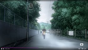
What is the best way to match the anime angle here?
Use Google Street View first to identify the slope shape and road curve, then visit in softer daylight when shadows are not too harsh for a closer recreation.

© 2026 Coser Map. All rights reserved.