cosermap logo
Local Weather
7-Day Forecast
Show Local Weather
Loading...

shuto expressway 1 haneda line

MIU404

Tokyo

Episode
Ep. 4
Time
-
shuto expressway 1 haneda line
  • Nearest Station: Tokyo Monorail Showajima Station
  • Walk: 25 minutes on foot
  • Best time to visit: Late morning or early afternoon on a clear day for better visibility of elevated road structures
  • Crowd level: Usually quiet
  • A roadway shot captures the elevated urban approach of the Shuto Expressway Route 1 Haneda Line during a tense transition in MIU404 Episode 4.
  • This moment appears as the investigation intensifies, using the Shuto Expressway and surrounding city roads to emphasize MIU404’s trademark sense of speed and pressure. While the frame does not focus on character expressions, the elevated roadway and dense urban infrastructure convey the urgency of the case and the feeling that the story is moving toward greater danger and the truth. In real life, the anime matches the Shuto Expressway Route 1 Haneda Line quite closely, especially in the direction of the elevated road, the guardrails, lane splits, and the metropolitan backdrop. Because scenes like this are shown from a moving vehicle’s perspective, the anime simplifies some signage and road details, so the real location has more complex signs, lane markings, and surrounding building textures. When comparing the two, the most recognizable elements are the curve of the elevated structure, roadside safety barriers, and the industrial waterfront skyline in the distance; the adaptation is most faithful in capturing the sensation of fast urban transit rather than reproducing every individual traffic sign exactly.
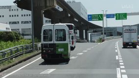
Can I stand on the Shuto Expressway itself to recreate this MIU404 shot?
No. The expressway is a controlled-access road, so fans should use nearby public streets, bridges, or pedestrian-accessible viewpoints instead of entering roadway areas.
Is Google Street View useful for matching this Episode 4 road scene?
Yes, but only partially. Street View around nearby surface roads helps confirm the elevated structure and urban layout, though exact expressway driving angles are limited.
What is the safest way to photograph this location for an anime pilgrimage?
Use sidewalks near public roads around the Haneda and coastal Ota area, and avoid stopping near ramps or restricted road shoulders. A zoom lens is helpful because the best matching features are elevated and not directly accessible.

© 2026 Coser Map. All rights reserved.