cosermap logo
Local Weather
7-Day Forecast
Show Local Weather
Loading...

shinjuku 5 chome east

Forest

Tokyo

Episode
Ep. -
Time
-
shinjuku 5 chome east
  • Nearest Station: Shinjuku-sanchome Station (Tokyo Metro Marunouchi Line, Fukutoshin Line, Toei Shinjuku Line)
  • Walk: 8 minutes on foot
  • Best time to visit: Evening or blue hour for lighting closest to the anime atmosphere
  • Crowd level: Moderate
  • A quiet Shinjuku street intersection is shown as an atmospheric cutaway, emphasizing the city's nighttime stillness.
  • No characters are directly visible in this moment; instead, the anime uses an empty Shinjuku street corner as an atmospheric transition that preserves the story's mood. It gives viewers a brief pause between character-driven scenes and highlights a sense of urban distance in the night. This kind of shot usually appears after a conversation, chase, or emotionally unsettled moment, using the quiet road, intersection, and city lights to extend feelings of hesitation, reflection, or anxiety before the story returns to the characters for the next meeting, farewell, or decision. The real-world match is a street intersection in the Shinjuku-5-chome-East area of Tokyo, and the anime recreates the road layout, corner building massing, traffic signals, and dense urban feeling with solid accuracy. At the same time, the animated version simplifies the clutter of real signage, overhead wiring, storefront details, and temporary roadside objects so the composition feels cleaner and more dramatic. In person, the area looks brighter, busier, and more lived-in than in the anime. When comparing the scene with Google Street View, the overall building shapes and street geometry are easy to recognize, though signboards, tenants, and facade details may have changed over time, so it is best to match the broader streetscape and viewing angle rather than relying on a single sign.
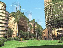
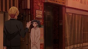
Which station is best for reaching the Forest scene at Shinjuku-5-chome-East?
Shinjuku-sanchome Station is the easiest access point, especially from the Fukutoshin or Marunouchi lines. Exit choices can change depending on construction, so check station maps before heading out.
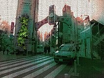
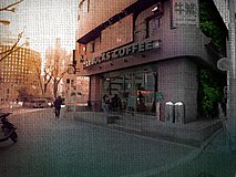
Can I recreate the shot easily, or has the street changed a lot?
The overall road alignment and corner building shapes are still recognizable, but shop signs and smaller facade details may differ from older references. Use Google Street View first to line up the wider intersection view.
Is photography allowed at this location for anime pilgrimage purposes?
Yes, casual photography from public sidewalks is generally fine, but avoid blocking pedestrians or shooting into private businesses. Nighttime tripod use can be troublesome in busy areas, so handheld shooting is the safer option.

© 2026 Coser Map. All rights reserved.