cosermap logo
Local Weather
7-Day Forecast
Show Local Weather
Loading...
nissaka
  • Nearest Station: Gokokuji Station (Tokyo Metro Yurakucho Line)
  • Walk: 12 minutes on foot
  • Best time to visit: Late afternoon or early evening for a mood close to the ending scene; clear days in autumn or winter work best
  • Crowd level: Usually quiet
  • A quiet sloping street at Nissaka appears in the ending, capturing MyGO!!!!!’s lingering mood of loneliness and fragile hope.
  • This ending shot closes on a quiet sloping street, with no characters clearly visible, yet it condenses the emotional core of BanG Dream! It's MyGO!!!!! into a single image of distance, confusion, and the slow process of reaching one another. After all the misunderstandings, stubbornness, and feelings the girls could not honestly express, the story does not end in a dramatic outburst, but in a lingering stillness settled into an ordinary corner of the city. The scene suggests that while they still carry their own anxieties, they have finally begun to move a little closer to each other, stepping forward with a mix of loneliness and hope. In real life, the Nissaka slope closely matches the anime in road angle, downhill composition, and the surrounding residential atmosphere, making it highly recognizable. The shape of the slope, the direction of the street, and the placement of nearby buildings all show careful background reference work. The anime likely simplifies wires, signs, and small urban clutter to create a cleaner and more melancholic ending image, while the real location changes with season, light, and parked vehicles. There is no major pilgrimage sign or large tourist marker here, so visitors should compare the slope and distant perspective quietly and respectfully without disturbing local residents.
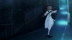
Is Nissaka easy to photograph for MyGO fans?
Yes, it is a public street and the ending angle can be recreated from the roadside, but it is in a residential area so keep noise low and avoid blocking traffic.
Are there any official anime signs or pilgrimage markers at Nissaka?
No major official BanG Dream! or MyGO!!!!! marker is known at this slope, so fans usually identify it by the road shape, incline, and surrounding houses.
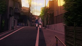
What is the best way to match the ending composition before visiting?
Use Google Street View first to check the downhill perspective and side buildings, then visit in softer late-day light for the closest atmosphere to the anime.

© 2026 Coser Map. All rights reserved.