cosermap logo
Local Weather
7-Day Forecast
Show Local Weather
Loading...
national route 134
  • Nearest Station: Koshigoe Station (Enoden Line)
  • Walk: 12 minutes on foot
  • Best time to visit: Late morning to afternoon in spring or on a clear winter day for bright coastal light
  • Crowd level: Moderate
  • A girl walks along a broad seaside road under a vivid blue sky, capturing the bright spring atmosphere of the episode.
  • This moment captures the bright, slightly dreamy spring atmosphere at the beginning of the story, with the character walking beside a coastal arterial road and the wide-open scenery emphasizing the light feeling of a new season beginning. The character’s expression is natural and calm, carrying a relaxed mood along with a faint sense of anticipation for the encounters and everyday changes to come. Rather than advancing through dramatic events, this part of the story gently builds the warm world of Supipara through the roadside scenery, the rhythm of walking, and subtle emotional movement between moments. The real-life location corresponds to National Route 134 in the Kamakura area, and the anime accurately recreates the long seaside roadway, the openness created by the sky and sea breeze, and the broad scale of the road itself. The easiest matching points on site are the coastal road layout, lane structure, and low roadside features, although the anime beautifies the background by simplifying wires, roadside clutter, and traffic information, making the frame feel cleaner and more transparent than reality. In an on-site comparison, the road shape, guardrails, signage, and seaside atmosphere are broadly faithful, but actual traffic is usually heavier and some signs have changed over time, so visitors often need to adjust their angle carefully to recreate the same clean composition.
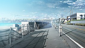
Is this Supipara spot easy to match from public roads?
Yes. The scene is along a public stretch of National Route 134, so you can compare the road line and coastal side safely from sidewalks without entering private property.
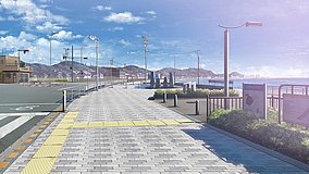
When is the best time to photograph this Route 134 scene?
Clear late morning or early afternoon works best if you want the bright blue-sky look seen in the anime. Sunset is beautiful, but it changes the mood and shadows a lot.
Can I use Google Street View to find the exact angle before visiting?
Yes. Street View along National Route 134 is very useful for checking guardrails, lane layout, and coastline alignment before your trip, though traffic and roadside signs may differ slightly from the anime.

© 2026 Coser Map. All rights reserved.