cosermap logo
Local Weather
7-Day Forecast
Show Local Weather
Loading...
Episode
Ep. エガクミライ
Time
2m 57s
ken do 134
  • Nearest Station: Shichirigahama Station (Enoshima Electric Railway / Enoden)
  • Walk: 12 minutes on foot
  • Best time to visit: Late afternoon on a clear day for coastal light similar to the anime
  • Crowd level: Moderate
  • A quiet stretch of roadside along Route 134 is shown as an atmospheric transitional cut in BanG Dream! It's MyGO!!!!!
  • This moment does not emphasize character expressions so much as it uses an empty coastal road shot to carry the pause in the story. By this point, the characters have just gone through emotional conflict and changes in their relationships that they still cannot honestly put into words, leaving them hesitant, restrained, and mentally unsettled. Instead of showing faces directly, the anime uses the street and distant view to create a sense of blank space between moving forward and standing still, quietly preparing for the choices the characters will soon make as they confront themselves and one another. The overall mood is calm, slightly bittersweet, and faintly forward-looking. The real location is along Kanagawa Prefectural Route 134, and the anime reproduces the road alignment, guardrails, and open coastal-road atmosphere quite accurately. The broad lateral road view and the straight rhythm typical of a seaside highway feel especially close to the real place. In reality, lane markings, traffic lights, utility poles, and nearby shop signage may have changed over time, so it is easier to match the overall composition and road shape rather than fixating on minor details. Scenes like this usually have no official anime marker or dedicated signboard, so fans generally identify the spot through Street View and the surrounding terrain. Using Google Street View makes it easier to see how the anime simplified the background and adjusted perspective. Because this is an active roadside location, visitors should prioritize safety and avoid stepping into dangerous positions just to recreate the shot.
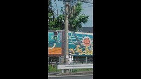
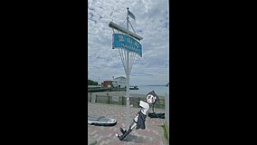
Is this MyGO!!!!! roadside spot easy to match from Google Street View?
Yes. The road curve, guardrails, and coastal alignment on Route 134 are the main clues, and Street View is the easiest way to confirm the angle before visiting.
Can I safely recreate the shot on ken-do-134?
Only from a safe pedestrian position. This is a live traffic road, so avoid standing near lanes or crossing just for the anime angle.
Are there any official anime markers or nearby fan signage here?
No official BanG Dream! marker is known at this exact roadside point. Fans usually rely on map pins, Street View comparison, and nearby Enoden-area landmarks when visiting.

© 2026 Coser Map. All rights reserved.