cosermap logo
Local Weather
7-Day Forecast
Show Local Weather
Loading...

county road 207 sharp curve

BanG Dream! It's MyGO!!!!!

Tokyo

Episode
Ep. エガクミライ
Time
2m 56s
county road 207 sharp curve
  • Nearest Station: Nishi-Kamakura Station (Shonan Monorail Enoshima Line)
  • Walk: 18 minutes on foot
  • Best time to visit: Late afternoon on a clear day, or early summer when roadside greenery resembles the anime mood
  • Crowd level: Usually quiet
  • A quiet roadside curve is framed as an atmospheric transition shot in BanG Dream! It's MyGO!!!!!.
  • This moment appears during a phase when the characters have not fully sorted out their feelings, and instead of focusing on them directly, the anime uses the scenery of a sharp bend in the road to express their uncertainty and the sense that they are about to take the next step. BanG Dream! It's MyGO!!!!! often uses overlooked urban corners and travel shots to reflect changes in relationships, so the curve and the road stretching ahead suggest that even though they are still uneasy about the future, they have begun to sketch out their own direction. In the surrounding story, emotional distance, pent-up feelings, and words left unsaid continue to build, which gives this seemingly calm empty shot a lingering emotional weight. The real-life counterpart is the sharp-curve marker area on Prefectural Route 207 near Kamakura, Kanagawa, and the anime is quite accurate in how it captures the road alignment and bend warning details. The curve itself, roadside guardrails, and the slightly enclosed feeling created by the road disappearing around the bend all match the location well. On site, the most recognizable features are the curve-related traffic signs and road markings; these are somewhat simplified in the anime but remain easy to identify. Seasonal vegetation, weather, maintenance of the pavement markings, and the placement of utility poles or small roadside fixtures may differ from the animated version, but as a pilgrimage spot it still strongly conveys how faithfully the series recreated the real terrain in its background art.
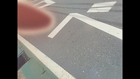
Is this curve easy to photograph safely for a MyGO pilgrimage?
It is a real roadside bend with vehicle traffic, so photograph only from the shoulder or other safe public space and avoid stepping into the roadway. A quick stop on foot is better than trying to linger in the curve itself.
What is the best way to match the anime angle at county-road-207-sharp-curve?
Fans usually compare the guardrail line, bend warning sign area, and road curvature first, then adjust for season and lens distance. Google Street View is useful here because the exact roadside geometry is one of the easiest matching points.
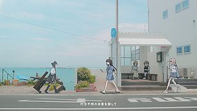
Are there shops or facilities near this BanG Dream! It's MyGO!!!!! spot?
This is mainly a residential hillside road, so facilities right at the curve are limited. It is best to use the station area for drinks, restrooms, and supplies before walking up.

© 2026 Coser Map. All rights reserved.