cosermap logo
Local Weather
7-Day Forecast
Show Local Weather
Loading...

chitose pedestrian bridge

BanG Dream! It's MyGO!!!!!

Tokyo

Episode
Ep. 3
Time
12m 12s
chitose pedestrian bridge
  • Nearest Station: Zoshigaya Station (Tokyo Metro Fukutoshin Line)
  • Walk: 6 minutes on foot
  • Best time to visit: Late afternoon on a clear day for lighting close to the anime mood
  • Crowd level: Moderate
  • Tomori stands alone on the Chitose pedestrian bridge, gazing out over the street in a quiet moment of isolation.
  • This moment appears during the early, heavy atmosphere of the story, with Tomori standing alone on the pedestrian bridge as if briefly escaping the pressure of school and difficult relationships. She struggles to express herself and is especially sensitive to emotional distance, so this elevated view over the street carries a strong sense of loneliness and self-protection. The scenes around it focus on her inner anxiety, the lingering pain of past band experiences, and her hesitation about connecting with others again, which gives this quiet location an unexpectedly weighty feeling. In real life, the composition of Chitose Pedestrian Bridge matches the anime very closely: the railings, walkway width, and angle over the road are all highly recognizable. The anime cleans up some background clutter to keep the focus on the character, so surrounding buildings, signage, and street noise appear simpler than on site. In reality, traffic signs, lamps, and roadside details are busier, and the look changes with season and lighting, but overall it remains a highly accurate and easy-to-compare pilgrimage spot.
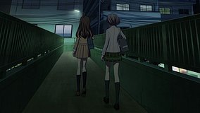
Can I stand on Chitose Pedestrian Bridge and take photos like in the anime?
Yes, the bridge is a public walkway and casual photography is generally possible, but do not block pedestrians or stop near stair landings. Use a phone or compact camera and keep your shoot brief.
What is the easiest station for visiting this MyGO bridge location?
Zoshigaya Station on the Tokyo Metro Fukutoshin Line is one of the closest and most convenient options. Gakushuinshita Station on the Toden Arakawa Line is also nearby if you want to combine multiple pilgrimage spots.
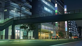
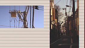
Is the scene still easy to match with Google Street View and on-site landmarks?
Yes, the bridge railings, road alignment, and surrounding street layout remain recognizable, making Street View comparison straightforward. Minor differences come from seasonal foliage, traffic equipment, and updated storefront details.

© 2026 Coser Map. All rights reserved.